| FindBook |
有 1 項符合
Historic Maps and Views of New York: Includes Frameable Maps and Views的圖書 |
 |
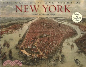
Historic Maps and Views of New York ─ Includes Frameable Maps and Views 作者:Vincent Virga 出版社:Black Dog & Leventhal Pub 出版日期:2008-06-01 |
| 圖書館借閱 |
| 國家圖書館 | 全國圖書書目資訊網 | 國立公共資訊圖書館 | 電子書服務平台 | MetaCat 跨館整合查詢 |
| 臺北市立圖書館 | 新北市立圖書館 | 基隆市公共圖書館 | 桃園市立圖書館 | 新竹縣公共圖書館 |
| 苗栗縣立圖書館 | 臺中市立圖書館 | 彰化縣公共圖書館 | 南投縣文化局 | 雲林縣公共圖書館 |
| 嘉義縣圖書館 | 臺南市立圖書館 | 高雄市立圖書館 | 屏東縣公共圖書館 | 宜蘭縣公共圖書館 |
| 花蓮縣文化局 | 臺東縣文化處 |
|
|
- 圖書簡介
A first-of-its-kind collection of twenty-four historic maps and views of New York City, specially bound so they can be removed easily and framed in standard-size frames.
Historic Maps and Views of New York is a unique and fascinating collection of twenty-four New York maps and views dating from the 1600s through the present. Included with each map is the original printing information and brief text that places it in historic context and further illuminates its qualities.
Put together by a map expert based at the Library of Congress, the selections include one of the earliest maps of Manhattan by Johannes Vingboons; views of New York Harbor in the early 1700s; an elaborately detailed map of Central Park; a complete topographical map of the island of Manhattan; an early subway map; overviews of Brooklyn and Queens; and much more. Each unique and stunning representation of New York is exquisitely reproduced to show off its color and detail, making it ready for display in any home, office, dorm room, or classroom. - 作者簡介Vincent Virga is a writer and picture editor. He is the coauthor, with the Library of Congress, ofCartographia: Mapping Civilizations (Little, Brown, 2007), The American Civil War: 365 Days (Abrams, 2006), andEyes of the Nation: A Visual History of the United States with Alan Brinkley (Knopf, 1997), which was a main selection of the Book-of-the-Month Club and the History Book Club. He's a native New Yorker who also lives in Washington, D.C.
The Old Building
Usborne English Readers Level 2 (共13冊)
Usborne English Readers Level 3 (共13冊)
Pip and Posy 英國版平裝本套書(共8本)*附音檔QRcode*
THE GREAT DETECTIVE SHERLOCK HOLMES 11: The Lethal Crystals
Jemima Small Versus the Universe
Usborne Illustrated Atlas of Britain and Ireland
Young Reading Series 3: The Invisible Man
Travel Puzzles (Never Get Bored Cards)
|


![塔木德:猶太人的致富聖經[修訂版]:1000多年來帶領猶太人快速累積財富的神祕經典 塔木德:猶太人的致富聖經[修訂版]:1000多年來帶領猶太人快速累積財富的神祕經典](https://media.taaze.tw/showLargeImage.html?sc=11100697818)


